Sunday, 28 September 2014

Rampur

Rampur is the city situated closer to Indo-Nepal border. You have to reach Rohilkhand district of Uttar Pradesh to reach Rampur city. This article is about the historical city of India popular for palace, national library and many other monuments. Basically, Rampur is the industrial state of India, but there are several tourist attractions that show the value of this city for tourism. Cotton mill and sugar refinery are main industries of the city. 


​Rampur region is the group of 4 villages founded by King Ram Singh. Later, the city was named as Faizabad. However, there are many other cities known as Faizabad so the city got the new name as Mustafabad (alias Rampur). This city is having black history as it played important role for British Army in the first Indian Independence War in 1857. The Nawabs of Rampur fought against the Indian army that helped the British rulers to control the war from northern portion.


​Rampur city is surrounded by Bareilly city in east, Udham Singh Nagar in north, Badaun city in south and Moradabad city in west. 


​Weather: If you are planning for Rampur then be aware that summer is hottest and not to visit period as the temperature goes to 43 °C most of the time. Winter is the best period to reach Rampur city. 

​Music: Rampur city is popular as the birthplace of many legends of Hindustani Classical Music. Rise of Gharanas Maihar and many more (music schools) are proof that people of city are music lovers. Some big names in Hindustani classical music legends are Ustad Allauddin Khan, Wazir Khan, Pandit Ravi Shankar, Vasant Rai, Nikhil Banerjee, Pannalal Ghosh, Sharan Rani and Bahadur Khan.


Knife making: If you are familiar with this city, then you might know that Rampur is famous for knife production as well. The best-known  Rampuri Chaaku is well known throughout the nation. However, the firms are not manufacturing big knives now onwards because state government has banned making such knives.


An attraction in Rampur:

Jama Masjid: Rampur is the Muslim city, and Jama Masjid is the initial spot to visit. This city was ruled by Nawab Faizullah Khan who built the Jama Masjid. Big market surrounding the monument is major attraction for visitors. 


​Raza Library: A public library established by Nawab Faizullah Khan is the next place to visit. However, the library was designed for his  use, but after independence, it is declared as public place. Raza library is listed as the biggest book collection store of Asia. Here you will find a collection of big scholars, painters, poets, calligraphers, literature and musicians. 

​Rampur Planetarium: A planetarium established by state government is another attraction for visitors. Sources say Rampur Planetarium is the first digital laser planetarium of India. 


Gandhi Samadhi: One of the major attractions of city is Gandhi Samadhi that is the memorial of Mahatma Gandhi. 


Kothi Khas Bagh: A special palace garden or Kothi Khas Bagh is located at Rampur. The spot is 30 km distant from Moradabad city of Uttar Pradesh. The palace is spread in 300-acre land designed in European style. 

Ambedkar Park: A memorial dedicated to Dr. Bhimrao Ambedkar is the next place to visit. The beautiful garden is located close to railway line.


Transport for Rampur:


By Rail: Rampur railway station is connected to big cities of India. Lucknow to Moradabad line is allowing voyagers to reach Rampur city. Trains for Rampur are available from Bareilly, Lucknow, Moradabad, Delhi, Jammu, Amritsar, Kolkata, and Kathgodam.


By Road: NH 24 is allowing a tourist to reach Rampur by road. State buses are available at every ½ hour from Moradabad. Direct transports for Rampur are attainable from Lucknow, Delhi, Bareilly, Haridwar, Aligarh, Rishikesh, Rupaidhiya, Kanpur, Agra and many other cities.

By Air: Closest airport for Rampur is Delhi located at distance of 300 km. Flights for Delhi are accessible from Lucknow, Dehradun, Chandigarh and many other cities.


Saturday, 27 September 2014

Sachen - Hill Station of Sikkim

For trekking Sikkim is the most difficult state in India. However, there are countless locations in this state so trekkers are getting an option for their adventure. We are discussing about Sachen hill station that is full of dense forest. The best feature of this town is you are getting complete jungle to live. Learn the real wildlife by attending this place. 

Sachen is the place that is not explored to the world. This is the reason you will not get the enough information about this town. Talking about development the city is not having many resources. It is the hill station having limited accommodation and facilities. You have to carry first-aid kit in case of any injury occur you can treat it with priority. The dense and the bad weather are always the concern of Sachen. You might face sudden rain or cloudy weather so it's better to carry raincoat or umbrella all time. 


Sachen is located close to another hill station of Sikkim known as Goechala La Pass. Goechala is famous for trekking and adventure lovers are reaching the town at frequent intervals. If you plan to reach Sachen, then you are getting the chance to visit Goechala as well. Next close tourist place is Yuksom that is one more trekking place. Talking about Yuksom it is the historical town of West Sikkim established in 1642 ADs. There are many base camps in Yuksom, but you have to register for this camp in advance. The seats are limited, and people from different origins are always trying to reach Yuksom.

Our prime target is Sachen, and it is the place that is not easily reachable. You can judge the difficulty of journey by watching the striking images. Get mentally prepared if you are not experienced with wildlife of Indian cities. The snakes and some wilder  animals are common in this area so keep yourself protected from any harm. Kanchenjunga National park is close to Sachen as well. 
How to reach Sachen?


Follow the road of Yuksom to reach Sachen. You can also connect to Goechala La Pass for our destinations. 

Friday, 26 September 2014

Kargil - Hill Station of Jammu Kashmir

The beautiful India is having attractive places to visit. You might hear about the Kargil war between India and Pakistan, but you will be surprised when you come to know that Kargil is the region of India that is famous for best scenery spots. Here you can enjoy the amazing valleys, wildlife and optimum hospitality of the local people. This region faced the big fight but still people are not scared, and even so, they are lively living.


Our prime target for the day is Kargil that is the district of Jammu & Kashmir state, India. Kargil is the hill station of India located Kargil closer to LOC (Line of Control) of India and Pakistan. West portion of town is boarded with Baltistan. One of the famous hill stations Zanskar is also covered under Kargil region. Few more amazing locations of Kargil region are Suru, Drass and Wakha valleys.


In 1947 when India became independent, it was partitioned into two different nations. That was the birth time of Pakistan resulting few big wars between India and Pakistani. Pakistan tried to capture the Kargil and many other cities of Jammu Kashmir state, though Indian force gave a good lesson to this country and defeated several times in big wars. Apart historical fights the city is holding amazing beauty. Experts suggest this place as heaven on earth and that is the reason tourists always look for the visit to Jammu and Kashmir cities at regular intervals.


Geographical structure: The Himalaya ranges with snow covered are easily visible to Kargil. Climate of the town is always chilled, though summer is the best period to visit. Temperature in winter goes to − 40 °C, though Kargil is holding record of − 60 °C as well. Another big chilled city of India known as Drass is located at an only gap of 56 km. NH 1 is the easy way to reach Kargil as this highway connects the city with Srinagar and other areas of the state. However, this highway is open from June to November only due to bad weather conditions. Zoji La is the big example of wonder highways of the world. This best Indian tourist place is located at 204 km distance from Srinagar.


Wildlife: Kargil town is beautiful, and its natural attraction is wildlife of the region. The most common sight for travelers in Kargil is Eurassian Magpie who is the big forest area of Ladakh. Snow leopard, Canis lupus langier (also known as Tibetan wolf), brown Bear (also known as Ursus arctos isabellinus), Ladakh urial, Capra ibex, Pikas, musk deer, Marmots and hares are available in the forest in large quantity.


The attraction of Kargil:
Pashkum: The wonder place of Kargil to visit is Pashkum located at 15 km distance from the town. Connect yourself to Pashkum through Leh road. A historical town with striking castles on hills is key attraction here. Learn the glorious past of Jammu and Kashmir State by visiting this town. 


Mulbek: Another tourist place in Kargil is Mulbek that is famous for Buddhist temples. Reach Mulbek located at 42 km distance from Kargil. Mulbek Chamba is key spot to visit in town that has 9 meters tall sculpture of Maitreya made of 7thcentury. The mosque and fort are two other attractions for voyagers in this town.


Shargole: If you love visiting villages, then attain to Shargole town located at 35 km distance. Person of this town is having huge faith in God Buddha. You will find maximum people of Buddhist community, though Muslims are also in the large amount in this town. The beautiful monastery with amazing paintings on the wall is major attraction here. Surrounding of Shargole can  make your holidays memorable. The picturesque view from the monastery could be different experience for you. You know the place is having four days trekking areas from Shargole to Suru valley. Check out some best images of Shargole on the Internet and you will come to know the value of this place. Daily buses are available from Mulbek to Shargole.


Fokar Urgiyan Rzong: Our next target of Kargil is Fokar Urgiyan Rzong located at the only gap of 8 km from Shargole. Here you can enjoy the citadel, water streams and dense forest. The cave monastery is prime spot to visit at this place.


Rgyal Wakha: There are countless places to visit in Kargil though Rgyal Wakha village is one prime spot located at few Km distances from Mulbek. You are going to visit the hidden vertical cliff formed by nature in Rgyal Wakha.


Drass War Memorial: Kargil war is listed in big wars of Indian history. Drass war memorial is the place created after Kargil war ends. The lists of all warriors who played important role in Kargil war are mentioned in this memorial.

Drass Memorial

54Some other best destinations of Kargil are Yuru Gompa, Suru Valley, Karste River, Phuktal Monastery, Rangdum Monastery, Sani Monastery, Nakpochu Valley and Karste Valley. Each spot is having a different feature so you are going to enjoy the spot so much. Kargil is an all-time favorite for nature lovers so visit the place with your family and make your holidays special.

How to reach Kargil?
By Air: Srinagar is the big international airport located in Jammu and Kashmir State. Srinagar is nearest considerable air hub located at 135 km distance from Kargil. Next closest airport is Leh airbase that is located at 138 km distance.

By Rail: Srinagar and Udhampur are two closest railway stations for Kargil. Udhampur is located at 202 km distance. Next big rail hub is Ram Nagar of J&K located at 209 km distance.

By Road: Kargil is easily connected to other cities of state through NH 1D. You can reach this valley town by road and can enjoy the beautiful journey because the whole path is full of adventure and dangerous turns.

Tuesday, 23 September 2014

Tanglang La

Do you love to visit the dangerous places? You will be surprised that Tanglang La is the route of India located in Leh region that is full of insecure curves and tiny roads. However, it is the most beautiful place because the maximum area is covered in the snow. The elevation of this town is 5,328 meters claimed as world’s 2nd uppermost route. 


Tanglang La is listed in most dangerous routes around the world, and that attracts the visitors so much especially the adventure lovers. This is the reason why the strength of visitors is increasing at this place. Frankly, this place requires some attention, and visitors must do essential steps for safe travel to Tanglang La. Local tourism buses, and private taxies are available for this high route, but if you are planning to go by your own vehicle, then you must carry the first-aid kit, warm clothes and a road map. 


​It could be the enjoyable journey, or it can be the most dangerous travel if you are not fit and mentally prepared for this location. The road is completely unpaved dirt, and the most dangerous part of this route is the top 20 km distance that is full of loose stones. You might feel difficulty of breathing on uppermost area because of low oxygen level. 


Tanglang La is a highway that connects Leh to other cities of J&K. You might face traffic on peak as the heavy vehicles are using this route as a transport medium. The impressive part of Tanglang La you will find the Buddhist flags of prayer in complete pass.


​The place is not holding any particular location for attraction, but the route that you are going to cross itself is the major attraction point of this town. The low oxygen and chilled temperature are enough to freeze your blood. Be careful if you have decided to visit this amazing tourist place of India. 


During the route, you will get lots of deep valleys. Take a break and enjoy the beautiful nature of Leh region. Tanglang La is full of dry mud but the high mounts, and the peaks are wonderful. Winter is the season when the maximum area is covered with snow that means if you reach Tanglang in winter you will face lots of difficulties to travel. 


​You can plan the trip after seeing the amazing videos of Tanglang La available on various media websites. The striking route and wonder scenery is enough to make the moment memorable. Risk is always there with challenging places, but the excitement level is also high of these locations. Both conditions match with Tanglang La pass. Enjoy watching Yak and several other animals during the journey. Stay in the village located near the Tanglang pass and take some rest, then continue your journey back to your destination. 


How to reach Tanglang La?
​The nearest big station for this pass is Jammu. The international airport is located at Srinagar that is close to Tanglang. Traveling to Leh allow visitors to connect Tanglang route. 

Monday, 22 September 2014

Chandertal Lake


Indian tourist spot team is reached to one of the best tourist attractions known as Chandertal Lake. Our team spend around 10 days in this place to learn why this place is so special for nature lovers. However, there are few things that really attracts the voyagers such as surrounding hills, crystal clear water of lake, greenery spread near the lake and of course the peaceful environment.


Chandertal Lake is the tourist spot located in Himachal Pradesh. This lake town is also known as Chandra Taal and Chandra Tal. The good altitude of 4300 meters is enough to learn that it is one of the coolest locations of India. The high hills of Himalayas with white sheet of snow was different experience for our team. In our early post of Spiti we discussed this location a little bit, though we are today here to so we came to know the value of Chadra Tal.


Lahul and Spiti itself are top areas for visitors which means if you are planning to visit Chandratal then you are getting two most impressive destinations to visit. We are pretty sure this could be your life’s best experience to visit Tal and other nearby places. Talking about the Tal this lake is just 1 km long but the chilled air and beautiful adjacent places are enough attractions for visitors. Trekkers are reaching the Tal at regular intervals and you can also see local people enjoying at this place. It is turned as favorite picnic spot for voyagers.


Here few things are important to discuss about this Tal. You have to reach Batal to attain to Chandra Tal, be prepared and don’t visit the location from October to March. The reason is chilled weather and bad rod conditions. The landslide and road block is common errors that people are getting while reaching to Tal. Kunzum Pass is another destination closer to Chandra Tal. For Kunzum you must plan a trip between May to October.


You have to go by foot from Batal, though road is available of 14 km from Batal but only two wheelers can go through the road. Wildflowers, lake and vast meadows are key attractions of Chandertal Lake. Your face is going to smile more when you come to know that the land area where the lake is located is known as Samudra Tapu so Lake name is Chandra (Moon) Tal (Pond) and land area is Samudra (Sea) Tapu (Small Hill).


How to reach Chandra Tal?
By Air: The biggest international airport for Chandertal is New Delhi. Flights for Delhi are available from domestic as well as abroad cities.

By Road: From Delhi you have to move towards Manali then Rohtang Pass, Gramphoo, Chattru, Batal and then Chandra Tal. If you are planning to go through Shimla then you need to cross Narkanda, Karcham, Nako, Losar, Kunzum and then Chandra Tal.

By Rail:Big junction for Chandra Tal is Delhi again. You can also get the train for Dehradun and from there you can plan trip from Shimla.

Sunday, 21 September 2014

Kanger Valley National Park


My recent tour to one of the exciting national parks of India

Kanger Ghati or Valley is the national park of India located Bastar region, Chhattisgarh.  Chhattisgarh is wonderful state having lots of green areas. However, some part to the state is dangerous as a local terrorist is active in such locations. Keeping such a thing in my mind, I was prepared to handle any type of situation. It was the most dangerous but exciting period to my life. Kanger Ghati is declared as National Park by Central government of India in 1982.


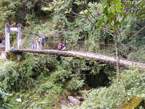
Kanger Ghati is having dense jungle and deep valley. KVNP or KGNP is the short name of Kanger Valley located closer to Jagdalpur city of Bastar district. KVNP is listed in most beautiful parks with and densest jungle of India. It is the Biodiversity location with finest landscape, splendid waterfalls, popular underground limestone caverns; Bastar mounts myna and house of birds. The experience I got in this park cannot be compared with any other place. It might be there are lots of wonder locations around the world, but still I believe KVNP is the top place for voyagers, especially for nature lovers.


Scenic Kanger Valley is 34 km long with Biosphere Reserve. However, I will not bore you with my experience; It's better to discuss the attraction spots of KVNP. This valley starts from Tirathgarh waterfalls and ends at the Odisha state border. The distance of the valley is 33 km and land area are 200 km2 wider.


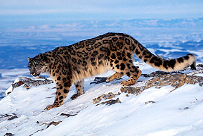
As KVNP is bio diversity area, and it is full of the jungle you will find the various flora and fauna here. Talking about wildlife of the park, there are countless animals to watch like Tigers, Mouse Deer, Leopards, Wild Cat, Sambar, Chital, Barking Deer, Langur, Jackals, Sloth Bear, Rhesus Macaque, Flying Squirrel, Wild Boar, Rabbits, Striped Hyena, Pythons, Cobra, Monitor Lizards, Crocodiles, Snakes and many more.


This park is located between the hill ranges known as Koleng and Kotamsar. The underground limestone cavern with drip stone is main attraction to the place.

Next attraction at the park is their waterfalls. Tirathgarh is the town having the best waterfall of the area. Kanger and Kolab are two major rivers flowing from this area.


Limestone Caves: There are huge limestone deposits in KVNP. You will be surprised after seeing these caves formed by the limestone. Some of the caves that are the world famous because of their layout are Kotamsar cave, Dandak Cave, Kailash Cave and Devgiri cave.

The key attraction of Kanger National Park
Tirathgarh Waterfalls: Striking place with best waterfalls. Local people refer this place as Milky Fall because of high-water pressure from the hills. The white color of flowing water from the rocks could be different experience for you.


Kotumsar Caves: Reach Kotumsar underground caves made of limestones. These caves are positioned at the only gap of 40 kms from Jagdalpur city. Such Caves are nearly 35 meters above the ground, and length is around 1371 meters.


Kailash Caves: The other place to visit in town Kailash Caves positioned in KVNP closer to Mikulwada. The distance between caves and Jagdalpur is 40 km.

Bhainsa Darha: A spot established at only 65 km distance from Jagdalpur. The river Kanger is always flowing with high pressure and because of that, many ponds are made. Remember one thing if you are planning to reach closer to this Darha, then you have to be very careful as Crocodiles are available here in the large amount.


Kanger Dhara: Another waterfall located in KVNP is the next place to visit located at 36 km distance from Jagdalpur city. The important feature of this place is you have to get the ticket and permission to reach Kanger Dhara. Visit the local forest department to get the permission as well as tickets for reaching the spot. This most interesting picnic spot is the best place for local people.

Dandak Cave: Last attraction of town is Dandak cave that is exactly same like Kotumsar Cave.


November to June is the best period to reach Kanger National Park.

How to reach Kanger Valley National Park?
Jagdalpur city of Chhattisgarh state is closest destination for KVNP. This city is connected through road from different cities of India. There are some barriers that you have to cross to reach the KVNP. For entering the park you have to reach Kotamsar and Netanar barriers. Kotamsar barrier is located at 27 km distance from City Jagdalpur. Buses for Jagdalpur are available from various cities of Andhra Pradesh such as Hyderabad, Vijayawada. The other barrier known as Netanar is located at 33 km distance from Jagdalpur. You have to cross Sargipal, the Bodal, the Murma, and then reach Netanar barrier.


The land area of park starts from 3 km of Netanar barrier. The major entry point of park starts from Kotamsar barrier.

By Air: Raipur is the closest airport located at 330 km distance from Jagdalpur.

By Rail: Jagdalpur is the closest railway station located at 27 km distance from Kanger Valley National Park.


By Road: Jagdalpur is the city having direct buses for KVNP. Reach Jagdalpur from Hyderabad, Bangalore and Vijayawada.

Saturday, 20 September 2014

Gulmarg - Hill Station of J&K


“धरती पर कहीं स्वर्ग है तो वो कश्मीर है।" 


This is the famous dialog that people say about Indian state Jammu and Kashmir. However, Kashmir’s maximum part is covered with high hills and snow. Our todays target for voyagers is Gulmarg that is one of the finest natural beauty spots of India. Gulmarg is the all-time favorite, though winter is chilled season and not easy for people to visit at such a period. It is the hill station popular for skiing event. If you have made your mind to reach this place, then you have to start your journey from Baramula (another hill station of Kashmir). 


​Gulmarg is located on LOC that separates the Pakistan from India. The view of Himalaya range is clear from this town. You must view the amazing pictures of this place before justifying that if the place is best to visit or not. The scenery, snow covered mounts, green valleys and twisted roads on hills are major attraction of this place. 

Climate: the important factor that needs attention while planning for Gulmarg visit. If you want to enjoy the greenery and the rose valleys then you can visit the town from April to October. Snow fall and the snow-covered peaks are visible from November to February. Maximum temperature of Gulmarg is recorded around 33 degrees celsius, and average minimum temperature is -4 degree Celsius. You will be surprised the town got the lowest temperature of -38 degree few years back. It becomes really difficult for voyagers to stay in winter season. 


​If you go through historical evidence, the city is named after Goddess Parvati. Here the Gauri (Parvati) + Marg (Meadow) turns into Gulmarg. Literature meaning for this word is Meadow of Mata Parvati. Lord Shiva’s temple is located in the middle of Meadow. In an ancient period, Gulmarg was the prime location for Hindu rulers. 


Gulmarg is absolutely reachable from Srinagar. If you are coming from abroad cities, then you can easily get the flights for Srinagar International Airport. Srinagar is the capital of Kashmir, and it is another tourist destination of India. The distance between Srinagar and Gulmarg is just 2 hours. Private taxi and buses are available from the outer area of Srinagar station. Tangmarg is the town comes between the journey of Srinagar and Gulmarg. 


​Nature lovers always look at the places that are full of beauty, scenery and stupendous valleys. Gulmarg is the Indian tourist place having amazing spots made by nature itself. 

An attraction of Gulmarg:
Gondola: Initial place of Gulmarg is Gondola that is the breathtaking place famous for Cable Car and skiing event. Gondola is just 1 km away from city bus stand. Lift ride of Gondola separates it into two segments. One starts from Gulmarg to Kongdoor and other from Kongdoor to Apherwat. The average height of this lift is 2690 meters to 3090 meters.


Snow Events: If you are the sports lover and want to enjoy the skiing events, afterwards reach Gulmarg. This city is also having snowboarding events that make it special destination then other locations of India. In winter, the whole area gets covered with thick white sheet of snow. The natural slopes Gulmarg hills are perfect for skiing beginners. You can also enjoy the paragliding and some other sky events in this place as well. 


Alpather Lake: Reach the next-best tourist place of Gulmarg established at the only gap of 13 km. It is the lake famous for serene and stunning view. Its shape is triangular placed perfectly with the picturesque surroundings of snowcapped peaks. The estates and gardens near the lake add charm to the beauty this place. Lake water gets a freeze in winter, though in summer you can enjoy watching floating ice pieces with flowing crystal-clear water. 


Baba Reshi Temple: Constructed in 1480 dedicated to Muslim Saint Reshi Baba. Baba was the imperative person during the ruling period of Monarch Zain Ul Abidin. The structural design of the temple is similar to structure of Mughals and Persian architecture. 

​St Mary's Church: An important place of worship located in the shepherd's valley of Gulmarg. This church was constructed by the British East India Company around 150 years back. 

Maharani Temple: Constructed in 1915 also known as Mohineshwar Shivalaya. The idol of Lord Shiva with Goddess Parvati is amazingly structured. Mohini Bai Sisodia was the constructor of this temple. It was built under the ruling of Maharaja Hari Singh of J&K. 

​Golf Club: Do you like to pay golf on high hills? Golf Club of Gulmarg was founded by British Government in 1911. The splendid green golf grounds are the best part to view in the club.

Travel options for Gulmarg: 
By Air: Closest domestic and international airport for Gulmarg is Srinagar located at only 56 km distance. Flights for Srinagar are available from Delhi, Bangalore, Chennai, Kolkata and many other cities of India. 

​By Train: Jammu Tavi railway station is the big rail hub to reach Gulmarg. It is located at distance of 290 km from Gulmarg. 

By Bus: Srinagar is the capital having beautiful roads with greenery. If you really want to enjoy the Gulmarg, then go by road. Direct buses are available for Gulmarg from Srinagar, Sonmarg and many nearest towns of Jammu and Kashmir.