Showing posts with label indian tourist places. Show all posts

Saturday, 29 November 2014

Khasi Hills - Beautiful Hill Area of Meghalaya

“Different destination diverse features” this is the common thought that comes in mind when we plan a trip on holidays. However, finding the best location for holidays is confusing task because there are numerous finest Indian tourist places when we search on google. Khasi Hill range is the place I have selected as the top tourism location of India for today. Khasi hills are basically part of Garo-Khasi area of Meghalaya. 


Earlier these hills were part of rich agricultural state Assam. Here travelers will get subtropical jungle Eco region that means if you reach this place you will get a chance to watch the natural beauty closer.

​If I say Khasi region is full of tribal then it’s somewhat true. Stunning images of Khasi states that how important this place is. There are countless waterfalls, jungle areas and reserve where you can visit in Khasi range. You might hear the world’s wettest place Cherrapunji that is closer to Khasi hills.


When we talk about Khasi Hills district it is divided in two parts, one is West Khasi and other is East Hills. The top peak of such range is Lum Shyllong at good altitude of 1968 meters from the sea level. However, Lum is just a few kms away in the south direction from Shillong town.

​Meghalaya state is mostly covered with hills, but some locations are too good to visit. You will not get similar destinations throughout the world and Khasi hill ranges are one of them. The headquarters is in Shillong for Khasi hills. As per census the average population of this location is 824,059 that is a big part of the whole Meghalaya population.


Geography: The district headquarters is in Shillong which is another quite tourist destination.

​Greenery, valley and jungles are the best tourist attractions of the Khasi hills. The north part of the hills are bounded by plain area of RI-Bhoi region. Rolling grasslands of the plateau of the Shillong are impressive and the river valley is another attraction for travelers. Once you reach the spot don’t forget to attain sharp waterfalls in the South direction of Khasi Hills. Some part of the hills are under the rural development block bordered by Bangladesh country.


Climate: Summer is hot, though winter is not that chilled but it is the best place to visit on rainy or winter season. Monsoon comes in May that continues till end of September. In summer you might face the humidity so you can plan a trip to Khasi hills between December and March.

Attraction in Khasi Hill ranges:

However, you will find limited areas in the Khasi hills for tourism though surrounding locations are available where you can reach on your holidays. You can enjoy the wonder hill areas and the stunning cities located closer to Khasi hills.


Such cities and tourism spots are mentioned in the below list:
  1. Shillong is the best holiday spot closer to this hilly region.
  2. Next place is Cherrapunjee that is wettest place of the earth known for living stem bridges.
  3. Nohkalikai Falls are listed as top waterfalls of the world. This fall is again closer to Cherrapunjee.
  4. Nohsngithiang Falls, Kynrem Falls and Umiam Lake are some more impressive spots closer to Khasi hills. Umiam is the manmade lake located on the way to city Shillong.
​Apart the mentioned places Mawlynnong village is another spot closer to Pynsursla block. This place is famous for its cleanliness so you must reach the village and enjoy their hospitality. Even you will face heavy rainfall in this village, but still the land areas are beautiful and completely clean. The root bridges, cottages and jungle areas are famous attractions of Mawlynnong village.


​How to reach Khasi Hills?
Reaching Shillong is the best option for Khasi hills and you will get the buses and private taxis for Shillong from various parts of Meghalaya state. Guwahati is properly connected to Shillong and Silchar is also having the direct connection through NH 44 to Shillong. Distance between Silchar and Shillong is nearly 240 km only.

The closest railway station for Shillong is again Guwahati that is connected to almost every big city of India. Umroi airport is available at only distance of 35 km from Shillong, but it is connected through private planes so you won’t get frequent service to reach the spot.

Saturday, 8 November 2014

Uttarakhand: This Rich Scenic Beauty State of India

Have you been to Uttarakhand? 

This is a very exciting Indian Tourist Place. Uttarakhand is a state at the Northern part of India. This place is formerly known as Uttaranchal. It was formed out from the North-western districts of Uttar Pradesh and the Himalayas on the 9th of November 2000. People also refer this as the Land of Gods as they believe that this is one of the most naturally bestowed states in India. Uttaranchal shares its borders in the north by Tibet, in the south by Uttar Pradesh, in the east of Nepal, west of Haryana and northwest of Himachal Pradesh. It is also the home to some of the finest Hindu temples and religious tourism destinations in India. It was in the year 2007 when Uttaranchal was renamed to Uttaranchai which means part of the North. The state covers the area of 20,682 square miles of land and the capital is Dehradun.


Attractions of the Uttarakhand:
Valley of Flowers National Park: This is an Indian National park in the state of Uttarakhand in the West Himalaya founded in 1931. It is popular for its meadows of endemic alpine flowers and variety of flora. 

Roopkund: In the Uttarakhand at the lap of Chamoli district, you will find a beautiful clear water lake called Roopkund. The starting point of your travel to Roopkund is Debal. You will find in this Indian Tourist place a picturesque lake that is surrounded by snow covered majestic Himalayan peak and glaciers. It is popularly called Skeleton Lake as this frightening area has 300 to 600 skeletons dated back 15th century AD. It is a one of the dreaded secluded places found in the regions of the Himalayan Mountains. 


Why do you think there are lots of skeletons there? 
Was there a mass killing or they we’re just struck by a super typhoon? 
Was it a mass grave or a sunken cemetery? 
Or a group travel to trek the mountains? 


Based on the local folklore there was a troop that earned the fury of the local deity called Latu and were caught by the mighty hailstorm, they were thrown in the Roopkund Lake. It was in 1942 when a British forest guard in Roopkund who made this alarming discovery. The lake which is full of skeleton is at the bottom of a small valley some 16,000 feet above sea level. It was summer when the ice is melting the shows more skeletal remain. 


There are some which are floating in the water and some are lying haphazardly around the lake’s edges. During the expedition in 2004 it revealed that the bodies were during the 850 AD. As checked in the DNA, there are two groups of people who died. One is a family or a tribe of related individuals and the second group are the locals which could be the porters and guides that were hired by the tribe. Based on the research, the 2004 expedition came into a conclusion that those 200 people died from a sudden and severe hailstorms. They were trapped in the valley and cannot seek shelter nor hide somewhere. The cricket ball sized hailstones which are hard as iron came and resulted for a sudden death of the travelers. The remains are at the lake for 1200 years until they were discovered. 


Kedarnath Mandir: This is one of the holiest Hindu temples that is dedicated to the god Shiva. It is on the Garhwal Himalayan range near the Mandakini River in Kedarnath, Ultrarakhand, India.


Nainital Lake: This is a natural freshwater body, at the township of Nainital in Uttarakhand India. It is tectonic in origin and shaped like kidney or crescent shape. It has an outfall at the south eastern end. 


Weather Conditions: 
Uttarakhand has two types of climates as it is differentiated in the plains and in the mountainous areas. The best time to visit the state is during summer when the weather is mild. There are some areas of the hills that become inaccessible in winter time because of prolonged snowfall. The plain region is best during winter as the weather is pleasant. During summer, the temperature is crossing the mark of 40° C while winter time can be chilly with the temperatures going below 5° C. Climate from the southern foothills averaging during summer at around 30° C and during winter time, the temperature is around 18° C. In the Middle Himalayan valleys, warm temperate conditions prevail, usually about the mark of 25° C. For the higher areas of middle Himalayan, summer temperature is mostly between 15 to 18° C and as winter approaches, the temperature will drop below the freezing point. The eastern flanks of the Himalayan ranges are subject to heavy rainfall while it is relatively dry at the western section.


Accommodation Status:
Since your travel would have a lot of walking through the fields, remote villages, pines and forest on the north western side of India, it is a great opportunity to vibe yourself in the ancient culture and meet the villagers as they welcome you to their way of life as well as their homes. As the traveler enjoys and experience the Himalayan village life, expect a simple bathrooms in outdoor wash-houses, no televisions or hair dryers, but don’t worry as there is electricity where you can charge your phone.  A short 4 day stay or longer hikes through the stunning Himalayan foothills, you will immerse yourself in village life with authentic home stays. The village folks would be gladly to serve you there authentic and delicious Kumaoni foods.


How to reach Uttarakhand?
The area is very remote. You need to take an overnight train ride from Delhi and then another 3 hour car journey to the hill station where you will start walking.

Sunday, 14 September 2014

Ziro - Hill Station of Arunachal Pradesh

Our purpose is to introduce known and unknown tourist destinations to the world. Today our prime target is Ziro that is the town of Subansiri region, Arunachal Pradesh. This wonder hill station of amazing state is popular as pristine towns throughout the country. Apani Tabu tribe is major spot of Ziro. 


Paddy and Fish system makes Ziro this town different than a whole country. Hapoli is nearest one more tourist place of India. Ziro is that beautiful that we can’t express its charm in words. You can view the stunning images through search engines. This Indian tourist place is full of greenery and trekking spots. If you have done trekking earlier than you will be surprised with Ziro as the location is having the diverse trekking site such as Talley Valley. This hot spot is famous as bio diversity town having beautiful Shiva Linga temple at Kardo. 


An attraction of Ziro:
Talley Valley Wildlife Park: A national park spread in 337 square km is leading attraction of town. Whenever you plan to visit a national park, you should gather some information like what is best of such a park. If we evaluate this forest, then you are getting a huge range of flora.  


Meghna Cave Temple: Shrines and holy towns are always more important for Indians. Where ever you go; you will find the temples and many religious spots as people from India having huge faith in God. Ziro is having caved temple known as Meghna. It is the ancient temple nearly 5000 years old rediscovered in 1962. 

Kile Pakho: A place located at the only gap of 7 km is another spot for tourism known as Kile Pakho. If you believe my words, I love nature places and Kile Pakho is one of my best natural beauty spots. Its scenery is delighted and if you check the reviews of other nature lovers, you will find this place as most demanding the favorite spot. 


Midey: Do you love blue pine trees? If so, then Midey is spot for you as the place is having full of biggest pine trees. To view these trees reach to Apatani Valley that is few km distances from Midey. 


Ziro Puto: The first hillock of Ziro declared after independence of India. Technically, the place is known as Army Puto. 


Ziro tourist attraction list is longer, and you can visit these destinations. Some of the key spots of Ziro are Dolo Mando, Hapoli, Dilopolyang Manipolyang, Pine Groove, Tarin Fish Farm, Bamboo Groove and Tipi Orchid Research Centre.  


How to reach Ziro?
The big closest station to reach Ziro is Itanagar located at 147 km distance. The other cities having direct connection to Ziro are Kohima at 526 km and Guwahati and 427 km distant. 

By Train: Tezpur is the closest railway station to reach Ziro. Trains for Tezpur are attainable from various cities of India. Local bus and private taxis are available from the outer part of Tezpur station. Tezpur is properly connected with Guwahati, Bangalore, Delhi, Hyderabad and many other cities of nation. 

By Road: Tezpur is the only city that is connected to Ziro through rail and road. You can get the buses from the Tepur for Ziro. Buses for Tezpur are accessible from Kolkata, Silchar, Itanagar, Lakimpur and few more cities of Arunachal Pradesh. 

By Air: Tezpur air hub is connected to Kolkata, Silchar, Delhi and many other cities of India. International visitors can reach to Kolkata to reach Ziro through Tezpur.

Sunday, 31 August 2014

Dodital Lake - Hill Station of Uttarakhand

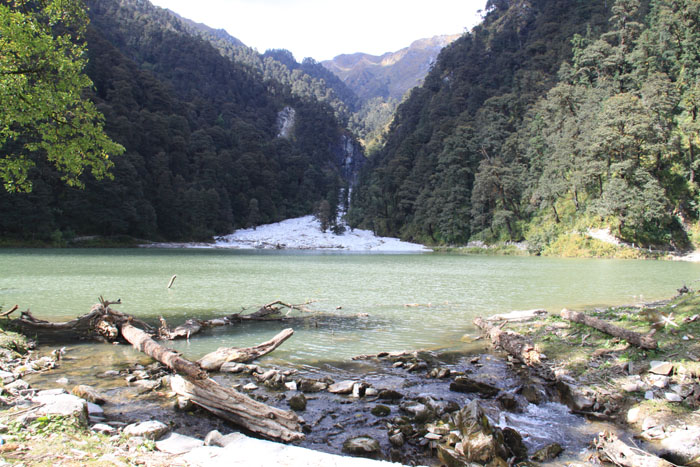
I love to reach hill stations or different adventurous places especially on vacations. However, my family is not having such interest. They believe to go to religious locations so I have made a plan to visit that place which is full of adventure as well as known for its religious values. Well! This time I am fail to find the religious place but I got a destination that is full of beautiful lakes and amazing hills stations with green valleys. Today my target at big Indian tourist place is Dodital. It is the place famous for freshwater lake located in Uttarakhand, India. The altitude of Dodital is 3,024 m from sea level. The town Dodital is having another name Dhundital. 


I love this place because of its natural beauty and I am sure you are also going to love this wonder destination. However, you have to reach Uttarkashi first to attain this place. From Uttarkashi you have to travel by road. You also have to walk for nearly few kms from Bebra to Dodital. I personally believe to enjoy the spot completely and always visit the nearby tourist place as well from my main destination. If you have enough time then you should plan your trip for nearly 1 week at least for Dodital. People believe the spot is named after Himalayan Trout's recognized as Dodi. If you love to live in place that is covered with dense forest then visit Dodital. Just at the end of forest you will see the Dodital lake of 1.5 km and a temple of Lord Ganesha.


Sangamchatti is one more impressive spot for you located at only gap of 21 km. Here you will get the chance of gentle trek of high hills. It is the possible station of overnight halt as well. Next nearby spot is Agora located at 7 km distance from Sangamchatti.


For accommodation you can try few forest guest houses at destination. The big benefit of stay in forest guest house is you can easily apply for permit for stay and forest safari from the office. People come with their own tents as well for camping. For food you can reach to small basic cafeteria.


I was reading on various website about the Dodital town and came to know that this place is having mythological values too. As per legends the God Ganesha select this spot as his domicile. Lord Ganesha temple is the proof of his devotees. The Dhundital Lake is named after Lord Ganesha’s name. The world Dhund-I-tal means Ganesh ka tal.


General Information:
Dodital is the hill station famous for amazing valleys and beautiful lake. The best period to reach the spot is among April to November. 6 days are enough to enjoy the spot completely, but you can spend more time as the valleys are amazing in appearance. Hottest temperature of city is 15¬¬¬0 C and coolest is temp is 00 C. Some big nearby tourist destinations are Uttarkashi, Agoda, Sangam Chatti, Dodital and Darwa. 


How to reach Dodital Lake?
The last 22 km simple trek to reach Dodi Tal starts from Sangam Chatti. If you have planned to reach Darwa Top then you have to move further. Road is available to reach Sangam Chatti from different areas of Uttarkashi.


Delhi is the major hub to attain Dodital Lake. Delhi is easily reachable through Meerut, Haridwar and almost every big city of India.