Saturday, 8 November 2014

Uttarakhand: This Rich Scenic Beauty State of India

Have you been to Uttarakhand? 

This is a very exciting Indian Tourist Place. Uttarakhand is a state at the Northern part of India. This place is formerly known as Uttaranchal. It was formed out from the North-western districts of Uttar Pradesh and the Himalayas on the 9th of November 2000. People also refer this as the Land of Gods as they believe that this is one of the most naturally bestowed states in India. Uttaranchal shares its borders in the north by Tibet, in the south by Uttar Pradesh, in the east of Nepal, west of Haryana and northwest of Himachal Pradesh. It is also the home to some of the finest Hindu temples and religious tourism destinations in India. It was in the year 2007 when Uttaranchal was renamed to Uttaranchai which means part of the North. The state covers the area of 20,682 square miles of land and the capital is Dehradun.


Attractions of the Uttarakhand:
Valley of Flowers National Park: This is an Indian National park in the state of Uttarakhand in the West Himalaya founded in 1931. It is popular for its meadows of endemic alpine flowers and variety of flora. 

Roopkund: In the Uttarakhand at the lap of Chamoli district, you will find a beautiful clear water lake called Roopkund. The starting point of your travel to Roopkund is Debal. You will find in this Indian Tourist place a picturesque lake that is surrounded by snow covered majestic Himalayan peak and glaciers. It is popularly called Skeleton Lake as this frightening area has 300 to 600 skeletons dated back 15th century AD. It is a one of the dreaded secluded places found in the regions of the Himalayan Mountains. 


Why do you think there are lots of skeletons there? 
Was there a mass killing or they we’re just struck by a super typhoon? 
Was it a mass grave or a sunken cemetery? 
Or a group travel to trek the mountains? 


Based on the local folklore there was a troop that earned the fury of the local deity called Latu and were caught by the mighty hailstorm, they were thrown in the Roopkund Lake. It was in 1942 when a British forest guard in Roopkund who made this alarming discovery. The lake which is full of skeleton is at the bottom of a small valley some 16,000 feet above sea level. It was summer when the ice is melting the shows more skeletal remain. 


There are some which are floating in the water and some are lying haphazardly around the lake’s edges. During the expedition in 2004 it revealed that the bodies were during the 850 AD. As checked in the DNA, there are two groups of people who died. One is a family or a tribe of related individuals and the second group are the locals which could be the porters and guides that were hired by the tribe. Based on the research, the 2004 expedition came into a conclusion that those 200 people died from a sudden and severe hailstorms. They were trapped in the valley and cannot seek shelter nor hide somewhere. The cricket ball sized hailstones which are hard as iron came and resulted for a sudden death of the travelers. The remains are at the lake for 1200 years until they were discovered. 


Kedarnath Mandir: This is one of the holiest Hindu temples that is dedicated to the god Shiva. It is on the Garhwal Himalayan range near the Mandakini River in Kedarnath, Ultrarakhand, India.


Nainital Lake: This is a natural freshwater body, at the township of Nainital in Uttarakhand India. It is tectonic in origin and shaped like kidney or crescent shape. It has an outfall at the south eastern end. 


Weather Conditions: 
Uttarakhand has two types of climates as it is differentiated in the plains and in the mountainous areas. The best time to visit the state is during summer when the weather is mild. There are some areas of the hills that become inaccessible in winter time because of prolonged snowfall. The plain region is best during winter as the weather is pleasant. During summer, the temperature is crossing the mark of 40° C while winter time can be chilly with the temperatures going below 5° C. Climate from the southern foothills averaging during summer at around 30° C and during winter time, the temperature is around 18° C. In the Middle Himalayan valleys, warm temperate conditions prevail, usually about the mark of 25° C. For the higher areas of middle Himalayan, summer temperature is mostly between 15 to 18° C and as winter approaches, the temperature will drop below the freezing point. The eastern flanks of the Himalayan ranges are subject to heavy rainfall while it is relatively dry at the western section.


Accommodation Status:
Since your travel would have a lot of walking through the fields, remote villages, pines and forest on the north western side of India, it is a great opportunity to vibe yourself in the ancient culture and meet the villagers as they welcome you to their way of life as well as their homes. As the traveler enjoys and experience the Himalayan village life, expect a simple bathrooms in outdoor wash-houses, no televisions or hair dryers, but don’t worry as there is electricity where you can charge your phone.  A short 4 day stay or longer hikes through the stunning Himalayan foothills, you will immerse yourself in village life with authentic home stays. The village folks would be gladly to serve you there authentic and delicious Kumaoni foods.


How to reach Uttarakhand?
The area is very remote. You need to take an overnight train ride from Delhi and then another 3 hour car journey to the hill station where you will start walking.

Thursday, 6 November 2014

Fatehpur Sikri: Historical Place of Uttar Pradesh

Every destination is having special features, though selection of tourist place is depend on interest of visitors. Fatehpur is listed in 71 regions of UP (Uttar Pradesh), India. It is one of my favorite Indian tourist places spread in 4,152 km² area. The average population of Fatehpur district is more than 2,500,000 according to 2001 Census. However, the city is positioned at the banks of holy rivers Ganga and Yamuna. This place is having historical values as well as and also mentioned in Puranic literature of India. Some popular ghats here are Asani and Bhitaura. 


When we plan to visit attractive places for holidays we also look for surrounding areas. This is because if we get spare time then we can enjoy some more locations at same time. Fatehpur is kind of similar location that is closer to two big cities of UP. Allahabad and Kanpur are such cities famous as holy cities of India. Allahabad is also recognized as Prayag, though Kanpur is famous for restaurants and temples. Allahabad is 117 km away and Kanpur is 76 km far from Fatehpur.


Talking about the tourist attractions of Fatehpur city there are limited locations to visit. However, city is having historical values so our travelers will not get bored in the place. Some best monuments, river sites, Ghats and several gardens are most impressive spots of Fatehpur. 

As we talk about the monuments of city the world famous Fatehpur Sikri fort is one of them. Here the key attraction in this fort are Diwan-I-Am, Diwan-I-Khas and Pachisi court. 


Fatehpur Sikri: A fort that is having Buland Darwaza (Biggest entry door), cabins, gardens and many other spots. To reach Sikri you have to cover the distance of 37 kms from Agra. Fatehpur city was the dream of Mughal Ruler Akbar. He decided to make first planned city of Indo-Islamic design in India. The fort is constructed in 8 square km area and its altitude is 194 meters from sea level. Best period to reach the Fatehpur Sikri is from October to March. However, winter is chilled here so you need to take warm clothes if you have planned in winter to visit this place. 


Buland Darwaza: All set the best attraction of Fatehpur Sikri to start. This is the biggest door to enter the fort of Fatehpur set in south direction. You will find countless mosques, small and big monuments inside the fort. A deep well closer to door is another attraction for voyagers. Some of the villagers show stunts on this well which is their earning system. If you can pay a certain amount you will see lots of amazing performances of the best divers of this well. The door itself was configured after 5 years of the fort completion. This door was configured between 1576 as a victory symbol Mughal Emperor Akbar. 


Jama Masjid: Next attraction of the fort is Jama Mosque listed as first building of the complex. Construction of this holy mosque was done in 1571 with massive entry to the square. In this masjid there are three Mihrab’s in each bay decorated with marble. 


Tomb of Salim Chisti: Mughal rulers were good for architectural structures. They showed their best designs in almost every monument and Fatehpur Sikri is having similar design as well.  Here you will find the white marble tomb of greatest Sufi saint known as Salim Chisti. This tomb is built inside the Jama Masjid's courtyard. It is the single floor building built closer to central chamber. Carved net in surrounding is protection the tomb from external harms. 


Diwan-I-Aam: One of the key attractions of the Fatehpur fort is Diwan-I-Am which is also known as Hall of Public spectators. It is the multi bayed pavilion of rectangular shape fronting the large space of monument. 


Diwan-I-Khas: A one more impressive location of Sikri is Diwan-i-Khas that is built for private audience. It is the plain square structure having four Chhatri’s. Diwan-I-Khas is popular for central pillar that is made of octagonal shaft. 


Ibadat Khana: A place of worship known as Ibadat Khana is next spot to visit here. Basically it is the meeting house constructed in 1575 by Akbar. 


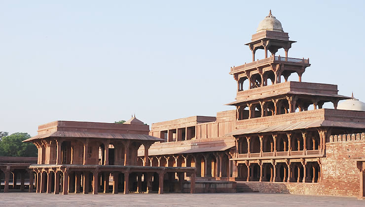
Anup Talao: It is the ornamental pool having four bridges. The key attractions of Anup Talao is royal enclave surround including Khwab Gah (means house of dreams). Panch Mahal and five-storey palace are few more impressive areas closer to this Talao.


Hujra-I-Anup Talao: One more spot identified as residence of wife of Akbar. 


Few other areas of Fatehpur Sikri are Birbal's House, Mariam-uz-Zamani's Palace, Pachisi Court, Naubat Khana and Panch Mahal. Birbal was the favorite minister of Akbar so a separate palace is designed for Birbal in the fort area. He was the only Hindu minister in Akbar Court. 

How to reach Fatehpur Sikri?
Closest destination to reach the destination is Agra (another impressive city of India).

By Air: Agra is having domestic airport that means you can reach our target space from any metro city of India. However, closest international airport is Delhi located at 180 km distance from Fatehpur Sikri.

By Train: You can easily avail the train for Agra from almost every city of India. Agra is the city of Taj and it is properly connected through train to all corners of nation. 

By Road: Fatehpur is reachable through road and state transport is available for the city. You will get plenty of buses and taxis from Agra, Delhi, Chandigarh and many more cities. Better to get the bus from Delhi as the multiple states are having buses from this capital city of India for various locations. Agra is next best city for state transport to Fatehpur City.

Wednesday, 29 October 2014

SeLa Pass - Highest Highway of Arunachal Pradesh

I feel wonder when I come to know about some of the best destinations of India. Today I am going to discuss about thee Sela Pass that is another highest highway of India connecting Tawang the top most tourist destination to our nation. General identification to this place is SeLa which means the La Pass. This is the high-altitude hill area comes under Tawang region, Arunachal Pradesh. The good elevation of 4170 meters from the sea level makes it most chilled pass of the India.


Lots of surprises are there on this route like you will get the snow covered peaks throughout the route. Se La pass is connecting you to Tawang the Buddhist city. The other end of this pass links you to another impressive city known as Tezpur. Later you will reach Guwahati and then so on.


No matter if you have plan to attain to Tawang you can get the Se La pass and can reach easily to Tawang that is located at only distance of 78 km, though Guwahati is 340 km away from Sela pass. Keep remember that you will not get any vegetation throughout the journey till Tawang. One thing is sure you will enjoy snow-covered locations at this place. It is preferred not to attain Sela pass in winter as the temperature goes to -10 degrees.


If I say the whole place is covered with snow throughout the year then it is right about the Sela pass. However, you can reach the spot in summer when the snow level is less. The excellent heavenly view of such place is major attraction for the travellers. Sela pass is having huge values for Buddhist people as they believe there are nearly 101 lakes existing in surrounding area of the pass. Among all Sela Lake is one of the beautiful lakes and because of its charm people referring it as Paradise Lake. It is partially frozen between Novembers to February so you need to be careful if you are thinking to walk on lake at such period.


Sometime the state government shut down the pass due to heavy snowfall in winter. Check the status of state government if you have plans for this place in winter. BRO (Border Roads Organization) is responsible to provide clear route to the passer-by. They work hard and give all efforts for smooth transportation in the area, though they block the route in winter for temporary if the conditions are worst.


Religion:
Sela Pass is important tourism place especially for Buddhists. You will monks and devotees of Lord Buddha during your journey.

Legend:
As this pass is connected to Tibet it is having historical values as well for the India. A story of brave Jaswant Singh is linked with this place as he was the Indian Army soldier who fought alone with Chinese soldiers in 1962 at the time of Sino-Indian War. Because of his bravery some part of the Sela pass is declared as Jaswant Garh. He died in the fight, of course fighting along with big army is not a simple task and surviving chances in such condition are nil. Jaswant Singh Rawat was awarded with Maha Vir Chakra for his devotion by the central government of India.


To impressive towns that are connected to both side of Sela pass are Bomdila and Jung so don’t forget to reach these places once you are pass.

For protection of route from enemy Indian army has based a big battalion at several points of Sela pass. Carry identification cards with you as army can ask for your identity at travel on this pass.


Overall, it is one of nature made beautiful place and you are definitely going to enjoy a lot at this Indian tourist place. Carry warm clothes as you might face chilled slaps of air at peak. This magnificent destination is having amazing Himalayan ranges surrounding. Your holidays will be memorable at Sela pass so prepare for it and give surprise to your family by taking them at highest highway of India


How to reach Sela Pass?
Closest big destination for our target is Tawang, though this city is having domestic airport and other sources like road service from different cities of India. Reaching this Indian hill highway is not easy task, but still you can attain to this place.

Tuesday, 28 October 2014

Khonsa: A Hill Station of Arunachal Pradesh

One of the exciting place known as Khonsa is our next target of the day. Khonsa is located at Tirap region, Arunachal Pradesh. This Indian tourist place is housing state school and some amazing tourist spots. You can find the people from different states in this town. The average elevation is 1215 metres from the sea level. It is the less crowded place and that is the reason it is peaceful and full of natural beauty spots. However, the town is having maximum strength of Christians, Baptist, and some Roman Catholics people. 


Without wasting any more time we will discuss the wonder locations of Khonsa. 

Attraction in Khonsa:
Khonsa is the wonderful hill station famous for receiving the first sun rays of morning in the world. Tirap Valley is key attraction here surrounded by the Himalayan peaks. Natural streams and dense forests with snowy hills are few more attractions of Khonsa. Trekkers are getting chance here as the peaks are rough steady. 


Khonsa Museum: Initial spot to visit in town is museum where you will get ample of information related to historical background of this place. The different culture, ancient swords and weapons are displayed in this museum. You will also get a chance to watch handlooms and art related collections here.  


District Museum: Another impressive location to learn more about the town. This museum was established in 1956 and it is full of artefacts collections. Don’t forget that the museum is open from Monday to Friday only.


Kheti And Lajo Village: The two small but impressive villages known as Kheti and Lajo are listed in 3 position of tourist attraction in Khonsa. These villages are symbolizing the tradition and culture of the ancient period. You can view the human skulls gathered from headhunting time of the town. 


Namdapha National Park: Khonsa is surrounded with deep valleys and dense forest which means you are getting a chance to enjoy the wildlife at this place. Namdapha National Park is located quite far from town as you have to cover the distance of 166 km to reach this tourism spot. Big cats, tiger, snow leopard, leopard and clouded leopards are majorly seen in this park. It was declared as wildlife sanctuary and tiger reserve in 1983.


Miao: Last destination for tourism in Khonsa is Miao that is another attractive place. Miao is only 154 km far from town Khonsa and it is the gateway to Namdapha National Park as well. Here you can enjoy scenic museum and a small zoo. If you are at Miao then don’t forget to visit Tibetan refugee’s camp.


Khonsa is the perfect destination for unwind and explore nature lovers. However, there are limited attractions in town, but each location is unique and beautiful. Wake up early in the morning and enjoy the first sun ray that comes on the earth. 

How to reach Khonsa?
By Rail: No airport is available in Khonsa so if you are coming through flight then check the flights for nearest airport Chabua. The distance between our destination and Chabua is only 77 km that is located at Dibrugarh, Assam. The next available airport is Rowriah at Jorhat, Assam and it is 132 km away from Khonsa. Both are domestic airports and you will get the flights from some major cities such as Delhi, Chennai, etc. for Chabua.

By Train: Closest railway station for Khonsa is Namrup located at 29 km distance. Frankly speaking train is best mode to reach this Indian tourist place. Another station closer to Khonsa is Borhat of Assam.

By Bus: State transport is available for Khonsa, though it is the preferred transport by experts because you will get lots of dangerous curves and highways with valleys and greenery if you go by road.

Monday, 27 October 2014

Bomdila: Hill Station of Arunachal Pradesh

I love traveling to different places and that makes me excited to learn about new destinations. My basic purpose for traveling is to discover such locations that are not explored to the world. India is the prime target as there are countless spots that are yet not known to the world, though these places are amazing and having world’s best attractions. 


Indian tourist place such as Bomdila is my target of the day. Frankly speaking this is the small urban city at good height of 8500 feet from the sea level not developed that much. Key attractions of Bomdila are landscape and snowy peaks. Such peaks are of Himalaya so it’s definitely going to be excited for the travellers.  


Bomdila is under Kameng region having some best attractive spots to visit. However, cool climate could be reason for the travelers and most of the time temperature is low. You can also enjoy the Apple orchards, snow-capped peaks and Gompas of Buddhist community. Few amazing spots of this town are described in this short note so that you can plan if the place is suitable for your holidays or not.  


Attraction in Bomdila:
Sessa Orchid Sanctuary: A park founded in 1979 is initial place to visit in Bomdila. This sanctuary is spread in 100+ square km area and Doimara & Tenga are two dense forests that you can enjoy here. This could be real jungle experience for you because the cottages in the forest are amazing. Deep valleys and high hills view are few more impressive part of this park. Some seasonal waterfalls are available too for the visitors. If you love to watch red panda then Sessa Sanctuary is best place for you. Avoid reaching here between April and October as it is the heavy rainfall period of this place. 


Eaglenest Wildlife Sanctuary: Adventurous people love to location that is more excited. If you feel the same then you are getting a chance to attain Eaglenest Wildlife Park that is close to Sessa Sanctuary. This national park is spread in 217 square km area offering remarkable views of waterfalls from low height. Kameng River is flowing from this region and this river is surrounded with the lush greenery. However, the park is not dangerous but you will find lots of adventurous spots here. Birds such as eagle, kingfishers, hornbill, pheasants and ducks are common to watch in this park. You might get a chance to watch Bengal tiger, Red Panda, Elephant, Langur, Black Bear and some more wild animals if you are lucky. 


Dirang Valley: Another place to visit in Bomdila is Dirang Valley that is impressive picturesque valley. It lies among Bomdila and Tawang (another big tourism place of India). Dirang is a town located in the valley and its weather is key attraction for people. Local people assist that there is a hot water spring in Dirang. The apple orchids and bird watching is favourite time pass at this place.
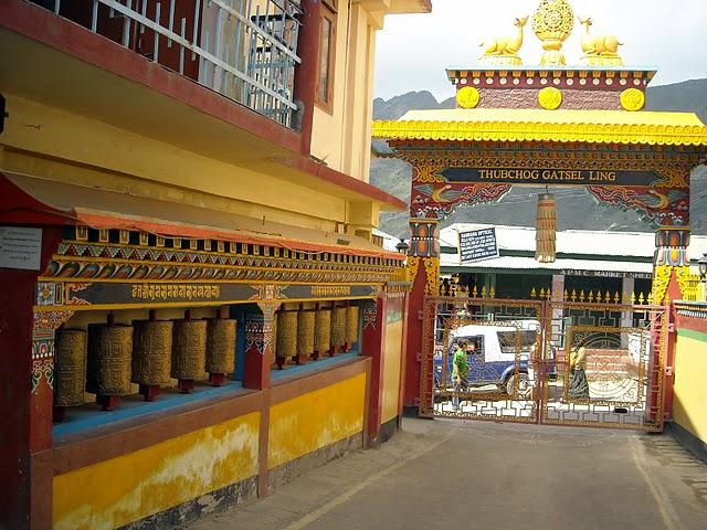


Bomdila Monastery: Established in 1965 represents the mystical essence of Buddhism, located near to TORC (Tipi Orchid Research Center) in Kameng region. Tsona Gontse Monastery at this place is similar to South Tibet monasteries so don’t forget to visit such wonder location. 


Bomdila View Point: As there are many viewpoints in Bomdila so you are getting points to watch nature closer. Bomdila View Point is spectacular and the highest peak is like breath-taking view of town. Nechipu Pass is easily viewable from this point. 


R.R. Hill: I believe hills are always best to visit and if you are in the same category then try to reach R.R. Hill that is Bomdila’s highest peak point. From this point you can easily vision border of Tawang and Bhutan.

Ethnographic Museum and Craft Centre: Learn history of Bomdila town by visiting museum. However, you are getting some handmade craft items at Craft Centre as well. You can buy hand woven carpets, wall hangings, traditional masks and many other products from this craft centre. People come to Bomdila use to buy dragon designed carpets. 


Tipi Orchidarium: A place that lies close to River Bharali is our next target of Bomdila. Arunachal Pradesh claims for major orchid ranges in our nation and Tipi is one of the key orchids in such list. There are nearly 50000+ orchid varieties here in Tipi including few rarest species. The big part of this orchidarium is some new hybrid types are developed by our scientists in their orchid research centre. You can also enjoy the rafting and fishing services in Tipi Orchidarium.


Upper Gompa: Major tourist loves to visit Upper Gompa located at high hill. This monastery is having another name as Gentse Rabgyel Ling Gompa. It is basically a school to educating monk kids. 


Lower Gompa: Like Upper Gompa there is Lower Gompa as well. However, it is positioned at the centre of Bomdila. There is a huge prayer hall and followers of Buddhist regularly visit this Gompa. 


Middle Gompa: Positioned near to the bazaar in Bomdila famous as oldest gompa of the town. It is basically a treatment center of town famous for healing with Blue Medicine.

Bomdila is the beautiful urban city, though it plays an important role for Indo-China border. Plan you trip and make your holidays memorable by visiting such a wonderful place. 

Best time to visit:
April to October is suggested as best period to visit this town.

Accommodation:
You will get local as well as some big lodgings, hotels and guest houses in Bomdila. Its better to book the room in advance as the place is having limited sources so you might get difficulty if you book in peak season. Online reservation is provided by some of the big travel organizations so take their help and get accommodation according to your comfort. 

Clothing:
The most important part of Bomdila is you should carry the warm clothing whenever you are planning to visit this place. 

How to reach Bomdila?
By Bus: Uttaranchal cities are quiet difficult to reach as the maximum portion is full of mountains. The closest big station to reach the spot is Tezpur that is under Guwahati region of Assam. You will get the good amount of private and state transport for Tezpur, though you get limited taxis and cabs to reach Bomdila from Tezpur. 

By Air: Closest airport for Bomdila is Tezpur, though it is the domestic airport so you will get the national flights to reach the spot. 

By Rail: Closest railway station that is properly connected to big cities of India is Rangapara, Assam.

Sunday, 26 October 2014

Pangot: Hill Station of Uttarakhand

Dream to reach best tourist place with our partner is always there in our mind. Today we are going to discuss about the location that is listed as beautiful hill station for couples. Pangot is the small but striking Indian tourist place comes under Kumon region, Uttarakhand. However, this hill station is only 13 km away from another stunning spot Nainital of Uttarakhand.

The most important part of Pangot is its pleasant climate, surrounding scenic scenery and layback appeal. People in large amount come to Pangot in summer holidays so we can say summer is the peak season to attain here. However, if you plan a trip in winter then you will be able to enjoy more because the peaks get covered with snow in winter and the appearance of the town becomes completely different. Snowfall is key attraction of winter in Pangot. 

We all know that Uttarakhand is housing countless amazing hill stations such as Dehradun, Nainital and many more. Pangot is similar place listed in best hill stations of India, though the place is quiet less popular so tourist strength is less compared to other hill stations of India. This is the reason many travel companies are having special packages for honeymoon couple.

If we talk about the favorite time pass at Pangot than maximum people will prefer bird watching. This is because birds from around the world come at this lake city especially in summer. You can easily find 150+ bird species such as lammergeyer, spotted forktail, blue winged minla, slaty forktail, rufous woodpecker, Khalij and yellow throated marten in Pangot. 

Some more attractive points of this wonder Indian tourist place are snow View Point and the Kilbury. No matter if you don’t like to roam much you can spend your holidays at Pangot and can enjoy the natural beauty from your resort or hotel room. The clear view of valleys, hills and scenic view is enough to make your moment memorable. If you have any stress or your life is full of tensions then you must reach Pangot to get relief from all such troubles. 

Don’t forget to enjoy the safari as the jungle of Pangot is full of mammals like civets, sambar, barking deer, gorals, leopard, and many more. You will be surprised that one of the biggest national parks of India known as Corbett National Park is at few km distance from Pangot. Hill stations are always full of adventure spots so as Pangot is. If you have any such intention then you can do the trek of rocky hills at this place. 

You will also find some seasonal streams here, but that you can enjoy only in rainy period. There are some lakes with crystal clear water and some downhill areas are also having ponds with clear water as well. Nearby lake places that are wonderful to reach such as Naini Tal, Naukuchia Tal, Saat Tal, etc. Short trek destinations that trekkers can enjoy are Naina Peak, Pindari, Namik and Nanda Devi. 

Accommodation and Food: 
Stay in Pangot is little trouble because accommodation is limited here. Some budget and regular-range lodges and hotels are available, but advance book is preferred if you are planning for Pangot. Big restaurants with all type of foods are available here. Better if you enjoy the local cuisine as you will get the different taste food of Uttarakhand in these restaurants. 

When to reach?
Pangot is having pleasant weather which means voyagers can attain this place round the year. Winter is preferred by the experts as visitors can enjoy the heavy snowfall occurs from November to February. Temperature goes minus 8 degree Celsius in winter so if you want to get chilled then go Pangot in winter. You must carry the worm clothes in summer as well because the average temperature of this place is between 10 to 25 degree Celsius. Peak season of Pangot is from June to September, though July to August should be avoided. 

Some nearby places that are famous closer to Pangot are Haldwani, Ukhimath, Dharchula, and Almora. 

How to reach Pangot?
By Air: Closest airport that is serving the nation with multiple airlines to reach Pangot is Pantnagar at 58 km distance. It takes nearly 1 hour to reach destination from the airport and private taxis are available for Pangot from the outer part of airport. However, flights are limited which becomes lesser in winter because of bad weather. Pantnagar is domestic airport and connected to various cities of India. 

By Rail: Nearest big railway station for Pangot is Kathgodam that is located at only distance of 20 km. Kathgodam is connected to almost every big station of India that means train is most suitable transport to reach Pangot. 

By Road: Uttaranchal state government is having direct buses for Pangot from internal cities as well as big metropolis of India. This tourism place is properly linked through road and you will get the plenty of bus services for Pangot.

Friday, 24 October 2014

Nallamala Hills: A Dense Forest of Andhra Pradesh

People from India is having special attraction for hill stations. Today we will discuss about the hill station known as the Nallamalas (also recognized as Nallamalla Range). Nalamala hills are basically in Kurnool region that spread to Mahabub Nagar, Prakasam, Guntur, Chittoor and Kadapa districts of Andhra Pradesh, India. 


This Indian tourist place is parallel to the coat Coromandel. Pennar and Krishna are two big rivers in this region and Nallamala hills are located between these two rivers. The two big peaks of this hill range are Bhairani at 1100 meters distance from the sea level and Gundla Brahmeswara at 1048 meters level. 


The interesting part of such hill area is there are some tribes living in the jungles of Nallamalla. In this region transportation is another big issue and you have to go by road if you want to reach this place. The famous Late Chief Minister Mr. YSR Reddy of Andhra Pradesh found dead in this forest after helicopter crash. The major part is forest department and government both did search for his dead body and it took more than 24 hours to find that. 


Weather:
Climate is almost hot of Nallamala and the average rainfall is 90 cm. Monsoon is better period to reach here as the temperature get quite manageable and greenery is spread everywhere. River Gundlakamma is the largest flowing river in such area. Winter is dry and average temperature recorded is 25 o Celsius.


Attraction in Nallamala hills:
It is a big jungle area, though the forest is spread in large amount so there is a risk of life if there is no proper plan. However, still there are countless locations where you can visit. 


Srisailam: The Initial place here is Srisailam that is a holy place, big power project area as well as dense forest area. Krishna River is the biggest source of electricity generator as the dam is constructed on this river at two different places. Sarisailm is one of them having large hydroelectric power station. Here the Lord Shiva temple is unique as well and devotees are reaching this place in large group. Few key attractions of this town are dam visit, swim in Krishna River, Shiva temple, jungle safari and local sightseeing. 


Mahanandi and Ahobilam Narsimha Temple: Another holy location in Nallamala ranges that is popular for descending stream from Gundla Brahmeswara peak. Both temples are ancient shrines and the local people is having huge values. A pool at this location is known as Nemaligundam (also referred as Peacock Pool).


River Krishna is listed as one of the big rivers of India and the high flow of water is amazing. You will find the countless small and big streams at different locations. A best than others waterfalls created by nature in this region is Mallela Theertham. 

Cumbum Lake: An oldest man-made lake of India nearly built in 15th century. The ruler of Gajapati Empire of Orissa ordered their architectures to create an artificial lake for harvesting water for 420 km 2 agricultural land of his limits. 


Few more impressive locations at this Indian tourist place are Mahanandi Temple built on foothills, Srisailam Gopuram, Dam view, Mallelatheertham Waterfalls, Upper Ahobilam temple and valleys. 

How to reach Nallamala Hills?
As the hills are spread in larger area so selecting best location then whole place is good option. Even the transportation is also limited and available for certain areas in this tourism place of India. Andhra Pradesh state is having transport for Srisailam and many other nearby towns and cities. 

By Road: If you are reaching in your own vehicle then get the highway of Vijayawada to Guntakal. A route is good, but covered with dense forest so be careful when you drive especially in night. Buses for Srisailam are available from almost every city of Andhra Pradesh. 

By Rail: Closest railway station for Nallamala hills are Hyderabad and Vijayawada.